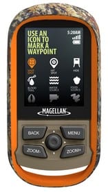
Magellan Launches eXplorist 350H GPS for Hunters at The SHOT Show
LAS VEGAS – SHOT Show, Jan. 14, 2013 – Magellan, a leader in innovative GPS devices for outdoor, fitness, automotive and mobile navigation, today announced the Magellan® eXplorist® 350H Outdoor GPS for hunters at the SHOT Show. The eXplorist 350H provides the features a hunter requires including pre-loaded detailed base maps with Game Management Units (GMU), Digital Globe satellite imagery for virtual scouting ability, hunting specific waypoints, hunting geofences, trail camera waypoint marking, and a camouflage exterior.
“The eXplorist 350H was designed to meet the hunter’s requirements with tools and features that will assist them whether it’s pre-season scouting or the hunt itself,” said Warren Hewerdine, senior director of marketing for Magellan. “Magellan is committed to serving the hunting community with high-quality, dependable outdoor GPS devices that bring together the best-in-class content, features, and ease of use.”
Preloaded on the Magellan eXplorist 350H is a custom detailed base map containing features needed by the hunter including GMU boundaries for the contiguous 48 U.S. states and for Alaska, and a 1:100k contour layer. This unique map also includes water features, urban and rural land use and a complete road network for the U.S., Canada, Western Europe, Australia, and major roads throughout the rest of the world.
Included with the Magellan eXplorist 350H is a one-year subscription to Digital Globe satellite imagery that gives hunters the ability to “virtually scout” a future hunt location from the comfort of their home by giving the hunter a satellite view of the area they plan to hunt. Hunters can quickly identify areas of interest such as game funnels, potential feeding areas, and suitable glassing locations. The areas of interest can be marked and waypoints loaded into the eXplorist 350H, ready for the field along with an area of Digital Globe satellite imagery.
Hunting-specific waypoints that can be used to mark animal tracks, rub marks, water and food sources while in the field are readily accessible on the Magellan eXplorist 350H and avoid the need to type names. Points marked in the field can be uploaded back into Magellan’s VantagePoint software application on a computer allowing any hunter, over time, to build up their own hunting specific database over time. In addition, the trail camera waypoint-marking feature makes it easy for hunters to mark the locations of each camera they place for monitoring their favorite hunting locations and then navigate back to them when needed.
When user-activated, the geofence feature of the Magellan eXplorist 350H will automatically alert the hunter when they are approaching any GMU boundary to ensure that the hunter stays within the area that they are permitted to hunt.
For maximum ease of use, the new Magellan eXplorist 350H comes with a totally redesigned user interface that offers a completely different way for the hunter to easily access the hunting specific features. Magellan’s eXplorist 350H is a lightweight, rugged, waterproof (IPX-7), handheld GPS receiver with a 2.2-inch color screen, and sports a camouflaged-colored exterior. Targeted availability is late Q2 of 2013 at $229.99 (MSRP).


